The following map of
Metro Denver Air Quality Monitoring Locations and Parameters Monitored was
created from (CDPHE, 2011a, Table 2). 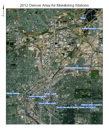
The following tables
show AQI levels of concern and associated health effects. 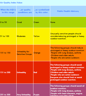 |
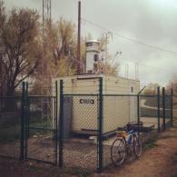
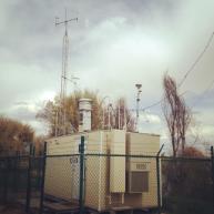
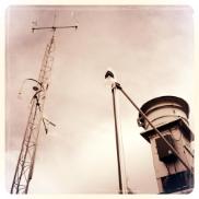
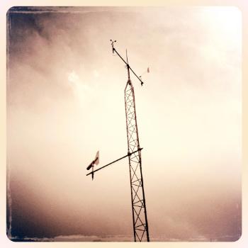
Air Quality: Air Monitoring Stations in the Denver AreaBy: Michael Garcia GEOG 5335 University of Colorado Denver, 2012 Air Quality is determined by the mixture of gases in the ambient air we breathe, and has direct effects on our daily lives. Air is continuously changing and quality is affected by both: natural phenomena, such as winds and wildfires; and anthropogenic sources, such as cars and power plants. Air Quality is monitored at over 60 separate locations throughout Colorado, by Colorado Department of Public Health and Environment (CDPHE), Air Pollution Control Division (APCD) (Colorado Department of Public Health and Environment [CDPHE], 2011a, p. 1). Monitoring stations assess ambient air quality by detecting levels of six Criteria Pollutants regulated by the Clean Air Act: carbon monoxide (CO), ozone (O3), sulfur dioxide (SO2), nitrogen dioxide (NO2), lead (Pb), and two sizes of particulate matter: inhalable particles smaller than, or equal to, 10 micrometers in diameter (PM10), and fine particles smaller than, or equal to, 2.5 micrometers in diameter (PM2.5). Monitoring of additional Non-criteria Pollutants is also conducted, although they have no current national ambient air quality standard. These include visibility reducing pollutants, total suspended particulates, and toxics. Meteorological measurements of wind speed, wind direction, temperature, and humidity are also recorded at many locations (CDPHE, 2011b, p. 6, 32). Air Quality Monitoring in Denver began in February 1965 as a part of the Federal Continuous Air Monitoring Program (CAMP). The CAMP station, at the intersection of 21st Street and Broadway, was thought to represent the best probability for detecting maximum levels of pollutants (CDPHE, 2011a, p. A-8). Today, there are 10 stations located in and around the metro area. Air Quality is reported by Air Quality Index (AQI) and Visibility Standards Index (VSI). AQI is reported daily. AQI is based on four criteria pollutants, and established national air quality standards, and the city of Denver must report AQI daily (EPA, 2009). AQI is divided into six color-coded levels of concern and values can range from 0 – 500. Higher values represent greater levels of air pollution and health concern. An AQI value of 100 generally corresponds to the national air quality standard threshold, while values over 300 may be hazardous to all groups of people. The city of Denver was the first U.S. city to monitor VSI. In 1990, The Colorado Air Quality Control Commission established a visibility standard for the Front Range cities from Fort Collins to Colorado Springs. An atmospheric extinction of 0.076 per kilometer was based on the public's perception and definition of unacceptable amounts of haze. This standard helped combat Denver’s infamous “Brown Cloud”. Monitoring is dependent on weather conditions, and VSI cannot be reported when visibility is affected by rain, snow, or high humidity. Visibility is monitored during daylight using a nephelometer. The transmitter component, on the roof of the Federal Building at 1929 Stout Street, sends a signal towards the receiver, near Cheesman Park at 1901 E. 13th Avenue. Visibility data, in conjunction with meteorology and pollutant concentration, are used to determine mandatory wood burning and voluntary driving restrictions (CDPHE, 2011b, p. 32) Daily Air Quality Summaries, Real-Time Air Monitoring Results, Air Quality Advisories, Interactive Maps and more Colorado Air Quality information is available through the CDPHE’s Air Quality website: www.colorado.gov/airquality
|